Public Rights of Way

West Berkshire Council manages around 740 miles of Public Rights of Way (PROW), so that local people and visitors can enjoy the countryside of West Berkshire. You can report a problem with a PROW in West Berkshire here.
Our online map shows Public Footpaths, Bridleways, Restricted Byways and Byways Open to All Traffic (BOATs), stiles, gates and steps in our district. You can read more about Rights of Way on the GOV.UK website.
The Definitive Map - Recorded Public Rights of Way
The Definitive Map and Statement (DMS) for West Berkshire.
Walking, Cycling and Horse Riding - Maps and Open Access Land
Cycling, riding and walking routes and maps in West Berkshire
Rights of Way Maintenance and Enforcement
Making sure our network is fit for use and taking steps when problems occur.
Closures, Restrictions and Motor Vehicles on Public Rights of Way
Legal closures and restrictions on West Berkshire Public Rights of Way (PROW) and use by Motor Vehicles
Preventing the Dedication of Public Rights of Way
Highway statements and declarations from landowners to prevent the creation of Public Rights of Way.
National Trails in West Berkshire
Information about The Ridgeway and Thames Path National Trails, and restrictions that apply
Cycling on Public Rights of Way
Information regarding which public rights of way cyclists can use
Local Access Forum
Improving access to the countryside through the Mid and West Berkshire Local Access Forum (LAF)
Public Rights of Way - Legal Order Priority Case List
Legal order cases prioritised for investigation this year
Notices - Recorded Public Rights of Way
Legal notices regarding public rights of way in West Berkshire
Public Path Orders
Legally diverting, creating or removing Public Rights of Way
Rights of Way Improvement Plan (ROWIP) 2025-2035
Improving our rights of way network and general access.
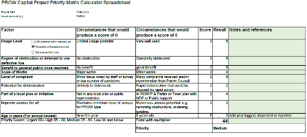
Rights of Way - Capital Projects
What happens to issues that have been reported to the Rights of Way team? How we asses them and prioritise action.


